Here's a somewhat unusual report: bushfires threatening houses on outskirts of Broome. It's unusual in that while the overwhelming majority of bushfire in Australia occurs in the north, rarely are human values like homes threatened. In fact, there have been few, if any bushfire-destroyed homes reported in northern Australia.
The linked story (very brief) reports 6 houses under threat from a fire 15 km east of Broome. It also notes 10 000 ha burnt. I estimated a much smaller amount of 3000-3500 ha using NAFI, but it is hard to tell exactly. The fire is not burning toward Broome at this time.
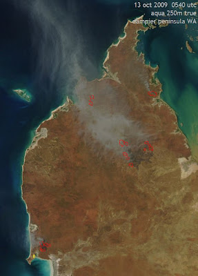
The image is the Aqua overpass from 13 October 2009, a close-up of the Dampier Peninsula in northwestern WA at 250 m resolution. The fires near Broome (B) are seen in the lower left corner. A smoke plume with several sources is visible, moving offshore to the west.
A much larger fire is also seen in the centre of the peninsula. A recent fire scar is apparent in the middle of the hotspots, as well as a thick plume of smoke. A very rough estimate of over 50 000 ha affected to date there. A few clusters of hotspots are also noted further north
Both of the main bushfires have been burning since Sunday. Both are visible in the yesterday's post on the Kimberley region at-large. The northern fire in particular had a dense plume in the image then. The weather is fairly typical for this time of year; temperatures in the upper-30s, low RH in the afternoon in areas not affected by the sea breeze and moderate, gusty winds often from the southeast. Fire dangers are running in the high to very high range. It is the peak of the fire season here

1 comment:
I drove through this fire tonight returning to Broome-after the road reopened. In some areas only the grass was burning, other areas trees crowning with fire, embers flying, the lot. Just outside town.
Post a Comment